Uttarakhand: Dharali Disaster Exposes Laxity in Monitoring Himalayan Threats
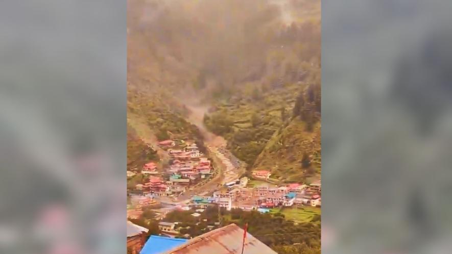
Image Courtesy: Screenshort from twitter/ @soumyajitt
India’s Himalayan states have been bearing the brunt of rising extreme weather events with the beginning of the Southwest Monsoon 2025, with a suspected cloudburst in Uttarakhand being the most recent one.
On the afternoon of August 5, a giant stream of water came gushing down the streets of Dharali village in Uttarkashi district, crumbling infrastructure on its way. While early visuals of the incidents indicated a possible cloudburst that triggered the flash floods, investigations are underway to ascertain the exact reason behind the catastrophic event.
Changing snowfall and rainfall patterns due to climate change have made the Himalayan mountains vulnerable. Glacier retreat and permafrost thaw have decreased the stability of mountain slopes and the integrity of infrastructure, cited in a special report on the cryosphere by the Intergovernmental Panel on Climate Change (IPCC).
Climate Science and Role of Climate Change
According to scientists, there is no doubt that the rise in temperatures and humidity in the region has triggered back-to-back extreme weather events.
Mahesh Palawat, Vice President- Meteorology and Climate Change, Skymet Weather, said, “With the axis of the monsoon trough running through the foothills of the Himalayas, we had already predicted a red alert for Uttarakhand. While the affected region is prone to cloudbursts, such a turn of events is due to the climate change-led rise in temperatures.”
He added that “a huge influx of moisture from the abnormal warming of oceans increases the capacity of the air to hold more water vapour. The Himalayas act as barriers, which give rise to vertically developed convective clouds, known as Cumulonimbus clouds. Sometimes, the vertical height of such clouds might even reach up to 50,000 feet. These clouds are like a column of water, which, when restricted due to topography like the mountains, can lead to the release of water over a smaller area in a shorter duration. This may lead to similar conditions to what we have witnessed in Uttarakhand.
Climate change has been consistently altering monsoon weather patterns, disturbing the distribution of the rainfall. Western Himalayan states, which are located on the northern edge of the Indian Monsoon, are highly vulnerable to heavy rainfall. Uttarakhand and Himachal Pradesh have witnessed several devastating floods exacerbated by rising temperatures. Rise in torrential monsoon rainfall spells across the Himalayan region can also be attributed to some bigger changes in atmospheric systems in the nearby areas.
According to a recent study, West Asia is undergoing an increase in land heating during spring, which is responsible for 46% of the intensified rainfall over Northwest India and Pakistan during 1979–2022. The transition region between the summer monsoon in South Asia and the desert climate in West Asia is shifting north-westward, posing a significantly enhanced risk of floods over Pakistan and North- Western India.
Raghu Murtugudde, Climate Scientist, Emeritus Professor, University of Maryland & Retired Professor, IIT-Mumbai, explains: “The rapid warming over the Middle East (West Asia) and the Mediterranean is a signature of global warming. This regional warming has been pulling the southwestern winds northward over the Arabian Sea. There is excess moisture being pumped into the Himalayan foothills. Similar conditions are being cited during the ongoing seasons as well. Because of this northward shift of the south-westerly winds, we might end up with more heavy rainfall events all the way into Himachal Pradesh and Leh Ladakh before the season is over.”
Moisture supply for the summer rainfall along the west coast of the Indian subcontinent is mainly transported from the Arabian Sea by the low-level jet (LLJ). LLJ is a fast-moving ribbon of air in the low levels of the atmosphere. The LLJ also feeds on the cross-equatorial southerly winds, which transport moisture and support the convection over the entire Indian monsoon region.
The West Asia warming is almost two times faster than other inhabited parts of the world. The warming has led to a poleward (northward) shift of the low-level jet over the Arabian Sea, causing a dramatic increase in atmospheric instability by thrusting moisture supplies northward. Consequently, the regions of Northwest India and Pakistan become unstable and favourable for deep convection (unprecedented rainfall).
In addition, the LLJ is accompanied by strong westerly winds and a pronounced positive vorticity (vorticity is a clockwise or counterclockwise spin in the troposphere), which provides a track for the invasion of the low-pressure systems into the region. This, additionally, transports moisture from the Bay of Bengal to further nourish the floods.
As a consequence, the summer rainfall is intensified over Pakistan and Northwestern India, which is roughly confined to 20°N−30°N and 65°E−78°E.
In summary, the sustained effects of spring land heating push the LLJ to the north, leading to an increase in vorticity and moisture supply to northwestern India and Pakistan, which eventually leads to enhanced rainfall over these regions during summer.
Himalayan Threats & Urgency of Monitoring Glaciers
The increase in rainfall extremes in high-elevation regions of the Northern Hemisphere is amplified, averaging 15% per degree Celsius of warming—double the rate expected from increases in atmospheric water vapour, according to a recent study, ‘Global warming intensifies rainfall in mountainous regions’. Moreover, more instances of extreme precipitation are in the form of rainfall than in snow. This is mainly because the zero-degree isotherm, the freezing level at which precipitation falls as snow, has moved to a higher elevation because of global warming. Now, most of the snow-bearing areas are witnessing rainfall. High-altitude regions are pinpointed as ‘hotspots’ that are vulnerable to future risk of extreme-rainfall-related hazards.
Experts have already warned against more intense rainfall bringing a greater risk of landslides in high-elevation regions, demanding the development of specific mitigation and adaptation plans at a faster pace. Due to climate change, hazards, such as glacier retreat, permafrost degradation and lake shrinkage, occur frequently in high altitude regions, often leading to slope instability and an increase in the occurrence of deep-seated landslides.
According to a research study, ‘Increase in occurrence of large glacier‐related landslides in the high mountains of Asia’, a total of 127 landslides were detected in the Landsat images of the study area, covering the period from 1999 to 2018. The landslides are mainly concentrated in the Karakoram Mountains, eastern part of the Pamir Mountains, western Himalayas and south of the Hindu Kush.
Subimal Ghosh, Institute Chair Professor, Department of Civil Engineering & Convener, Interdisciplinary Program in Climate Studies-IIT Mumbai, says: “With per degree centigrade warming, the extreme precipitation increases by seven to eight percent, and this is what we are witnessing at present. With climate change, extreme weather events are increasing and will continue to rise in the coming years as well. We have to equip ourselves in a better way, so that we can really manage the increasing extremes. We should have early warning systems and better adaptation designs, which are very much needed at the moment.”
Ghosh added that “it is very important to have floodplain zoning and to identify the regions that are extremely prone to flooding. If there is an early warning of extreme precipitation, immediately carry out evacuation from the region under the extreme flood zone. We should learn from how we have handled cyclones. We need to list the places according to the danger levels and that is how only we can save people.”
Under the influence of global climate change, the Himalayas are warming at three times greater than the global average rate. Rising temperatures have intensified the problem by accelerating the melting of Himalayan glaciers and loss of snow cover. This rapid melt fills glacial lakes more quickly, increasing the risk of overflow and downstream flooding. Additionally, the thinning of glaciers contributes to the destabilisation of mountain slopes.
Further, rampant development of infrastructure, such as hotels, tunnels, roads, and hydropower projects in the ecologically sensitive region, has aggravated the situation and economic losses.
Commenting specifically on Uttarakhand, YP Sundriyal, Adjunct Faculty- Geology, Doon University, Uttarakhand, says: “The role of global warming is already established in the rise of extreme weather events. We did not learn anything from the past disasters in 2013 (Kedarnath) and 2021 (Rishiganga). Why have there been no checks on unplanned construction in the region?”
He highlighted that “ecologically, the Himalayas are very fragile as these are the youngest mountain range in the world. This makes it a very sensitive region. The authorities concerned and local bodies should include scientists while carrying out any construction in the region, as they are well-versed in the geology. When such torrential rainfall occurs over hill slopes, it becomes more dangerous as debris flow leads to erosion due to landslides, making flash floods more powerful and disastrous.”
Sharing his views on the Dharali disaster, Anjal Prakash, Clinical Associate Professor (Research) and Research Director, Bharti Institute of Public Policy, Indian School of Business and IPPC author, said “such devastating events in Uttarkashi and other hilly regions highlight the increasing frequency of cloudbursts and flash floods driven by climate change. Unfortunately, India is not doing enough to develop climate-resilient infrastructure that can withstand these extreme weather events. To safeguard communities and manage natural resources better, it is crucial to invest in adaptive infrastructure and establish more monitoring stations in the Himalayas and their upper reaches. Enhanced surveillance and early warning systems are vital in addressing the increasing frequency of extreme weather events like cloudbursts and flash floods. “
He further added, “Without immediate action, these disasters will only become more frequent and severe, risking lives, homes, and livelihoods. Automatic Weather Stations (AWS) play a vital role by providing real-time data from the Himalayas, especially in their upper reaches. This information helps authorities issue timely alerts, enabling communities to prepare and evacuate in advance, thus saving lives and reducing damage. Given the rising intensity of climate-induced disasters, India must expand its network of AWS and invest in advanced forecasting technology to build a more resilient and prepared society.”
The Wadia Institute of Himalayan Geology have observed that glaciers in the Garhwal Himalaya show significant heterogeneities in glacier thinning and surface flow velocity patterns. The observations show an overall retreat of glaciers with variable rate of melting and retreat based on different facets like topography (elevation, aspect and slope), climate (temperature and precipitation) and debris cover. The observed retreats are 15-20 m/year for the Dokriani Glacier in Bhagirathi basin, 9-11 m/year Chorabari Glacier in Mandakini basin, 12 m/year at Durung-Drung and ~ 5.6 m/year at Pensilungpa glaciers in Suru basin.
The writer is a freelance journalist.
Get the latest reports & analysis with people's perspective on Protests, movements & deep analytical videos, discussions of the current affairs in your Telegram app. Subscribe to NewsClick's Telegram channel & get Real-Time updates on stories, as they get published on our website.